|
Size: 9333
Comment:
|
Size: 13730
Comment:
|
| Deletions are marked like this. | Additions are marked like this. |
| Line 3: | Line 3: |
| {{elevation.png}} | {{attachment:elevation.png}} |
| Line 5: | Line 5: |
| The first server-sat arrays will be deployed in a "4 hour" orbit, or more precisely a 23.9344696/6 = 3.989078 hour or 14360.7 second orbit (sidereal). This means it passes over the same spot on earth 5 times per day ( = 6-1, the earth is turning underneath once per sidereal day ). A 4 hour equatorial circular orbit has a radius of 12770 kilometers, and an altitude above the equator of 6399 kilometers. This puts it in a "thinner" part of the Van Allen belt, with an estimated unshielded radiation dose of 1Mrad/year [citation needed]. | [[EarthOrbits|here is a general discussion of orbits]]. |
| Line 7: | Line 7: |
| Relative to a position on the earth, a serversat will be visible in the same position 5 times per solar day, at intervals of 288 minutes. The constellation of associated orbits will therefore be called the '''m288''' constellation. Of course, higher and lower orbit constellations are possible, though they will get more radiation. The m240 constellation will repeat 6 times per day, and the m360 constellation will repeat 4 times per day. For reasons that will become apparent, it is important that the orbital period is an integer fraction of a day. | The first server-sat arrays will be deployed in a "4 hour" orbit, or more precisely a 23.9344696/6 = 3.989078 hour or 14360.7 second orbit (sidereal). This means it passes over the same spot on earth 5 times per day ( = 6-1, the earth is turning underneath once per sidereal day ), for a repeat time relative to the ground of 288 minutes (which we will call an m288 orbit). A 4 hour equatorial circular orbit has a radius of 12789 kilometers, and an altitude above the equator of 6411 kilometers. This puts it in a "thinner" part of the Van Allen belt, with an estimated unshielded radiation dose of 1Mrad/year [citation needed]. Relative to a position on the earth, a server-sat will be visible in the same position 5 times per solar day, at intervals of 288 minutes. The constellation of associated orbits will therefore be called the '''m288''' constellation. Of course, higher and lower orbit constellations are possible, though they will get more radiation. The m240 constellation will repeat 6 times per day, and the m360 constellation will repeat 4 times per day. For reasons that will become apparent, it is important that the orbital period is an integer fraction of a day. |
| Line 11: | Line 13: |
| Server-sats will actually be deployed in very slightly inclined and elliptical orbits, which map onto a nested set of torii ("torus-es") centered on the 4 hour, zero-inclination equatorial orbit. These are 4 hour orbits as well, and the largest torii are have major radii slightly offset inwards. A plane drawn perpendicularly to the center orbit (which intercepts the orbit in two places, and also intersects the center of the earth) will have "territories" marked on it for the regions around the various orbits, and the orbits passing through each "territory" can be treated as a property. This orbital property is further subdivided into angles around the orbit. Server-sats precisely positioned in each orbit will never intersect server-sats in other properties. Arrays in orbits in the same "property" will never intersect the orbits of arrays in different properties. This allows a large region of space to be filled with server-sats, potentially trillions of them. The density is limited by shading - at some point server-sats closer to the sun will reduce the daylight falling on the ones in the "back" of the orbit, and may begin to detectably reduce the sunlight falling on the earth. | Server-sats will actually be deployed in very slightly inclined and elliptical orbits, which map onto a nested set of tori ("torus-es") centered on the 4 hour, zero-inclination equatorial orbit. These are 4 hour orbits as well, and the largest tori are have major radii slightly offset inwards. A plane drawn perpendicularly to the center orbit (which intercepts the orbit in two places, and also intersects the center of the earth) will have "territories" marked on it for the regions around the various orbits, and the orbits passing through each "territory" can be treated as a property. This orbital property is further subdivided into angles around the orbit. Server-sats precisely positioned in each orbit will never intersect server-sats in other properties. Arrays in orbits in the same "property" will never intersect the orbits of arrays in different properties. This allows a large region of space to be filled with server-sats, potentially trillions of them. The density is limited by shading - at some point server-sats closer to the sun will reduce the daylight falling on the ones in the "back" of the orbit, and may begin to detectably reduce the sunlight falling on the earth. |
| Line 13: | Line 15: |
| Serversats will be spaced perhaps 100 meters apart in an array - an array with 32768 server-sats will be 3.2km on a side. This puts them far enough apart that the shade area behind one 0.3 meter diameter server-sat will never completely block sunlight to the server-sat behind it. If the nested torri extend outwards to 500 km around the central orbit, that is a spatial volume of 3E10 cubic kilometers. Potentially, that is room for 30 trillion server-sats at a 100 meter spacing. This "fuzzy toroidal cloud" of server-sats will block some sunlight, both to the server-sats in the back of the toroidal cloud, and to the surface of the earth. With 30 trillion 300mm diameter server-sats, the blockage would be about 7% at noontime on the equator. However, it is hard to imagine needing that many server-sats, even if they were operating mostly as space solar power satellites, beaming about 5 watts each to the ground, as that far exceeds the projected world demand for electricity. | {{attachment:eclipse.png}} === Shading === Server-sats will be spaced perhaps 100 meters apart in an array - an array with 32768 server-sats will be 3.2km on a side. This puts them far enough apart that the shade area behind one 0.3 meter diameter server-sat will never completely block sunlight to the server-sat behind it. If the nested tori extend outwards to 500 km around the central orbit, that is a spatial volume of 6E10 cubic kilometers. Potentially, that is room for 60 trillion server-sats at an average 100 meter spacing. This "fuzzy toroidal cloud" of server-sats will block some sunlight, both to the server-sats in the back of the toroidal cloud, and to the surface of the earth. With 60 trillion 300mm diameter server-sats, the light blockage to the ground would be about 14% at noontime near the equator, with the blockage zone following winter as shown above. The blockage of back server-sats near the sides of the orbit would be more severe - at the equinoxes, it could be as much as 95% for portions of a fully populated array. However, it is hard to imagine needing that many server-sats, even if they were operating mostly as space solar power satellites, beaming about 5 watts each to the ground, as that far exceeds the projected world demand for electricity. With a "mere" 10 trillion server-sats, the blockages would be 2% to the ground and 38% to the back of the array. Also, for power production (and one-way information broadcast) ping time is no longer an issue, so m360 and higher orbits can be used. === Nighttime Illumination === Server-sats will reflect some light. Oriented directly at the sun, most of the reflected light will go back to the sun, but some reflection will be diffuse and off angle. The sum of the diffuse reflected light from trillions of server-sats will appear as cloudy light in a band around the equator, interrupted by the Earth's shadow. At the equator, the illuminated bands will be about 9 degrees wide, and travel up from the horizon to within 30 degrees of zenith, and will be brightest just before the terminator. How much light? For 10 trillion (1E13) server-sats, a very full constellation, the total light will be about '''20 times the total light from the full moon'''. The moon has an albedo of 0.12, and so it reflects about 1.5E15 watts of light into a solid angle of 2pi steradians. At 384000km away, we see about 1.6 milliwatts of light per meter^2^ ( approximately 0.27 lux). A serversat will diffusely reflect perhaps 5% of the 130 watts of sunlight hitting it. The visible 1/3 of 10 trillion serversats would reflect 2E13 watts of light, also into a solid angle of 2pi steradians. At an average of 10000 kilometers distance, the surface at the equator gets about 30 mW/m^2^, or approximately 5 lux. Since recommended office illumination is about [[ http://en.wikipedia.org/wiki/Lux | 300 lux ]], that is way too much nighttime illumination! Without much better control of reflection, the total number of server-sats in at m288 will be limited by light pollution, probably to a small fraction of full moon light. '''This will probably limit the near-earth constellation to about 100 billion server-sats'''. If 10 trillion server-sats are deployed deployed as far out as the earth-moon L4 and L5 Lagrange points, the situation is much better. The constellations will be visible as often as the moon, though 60 degrees offset to east or west. On average, each constellation of 5E12 serversats will be reflecting 3E13 watts, and at the same distance as the moon, each will appear to be about 2% of the brightness of the full moon. It is even better at the earth-sun Lagrange points. We can dissipate another 100 Terawatts if we allow the earth to heat up by 0.4C. If that power is produced by 10 trillion server-sats, the reflected light might be 6E14 watts (we can see the whole constellation), but the light reaching us 150 million kilometers away is only 4 nanowatts/m^2^. === Elevation above the horizon, interference with geosynchronous satellites === |
| Line 16: | Line 35: |
=== Intentional gaps in the constellation === |
|
| Line 23: | Line 44: |
| == Collisions == | === Defining Property Within the m288 toroid === |
| Line 25: | Line 46: |
| The server-sats have limited maneuvering capability, but they travel in a "pure physics" region - their position and their orbit can be tracked and predicted down to the millimeter level. They are far enough up that solar maximums will not cause increased drag, and well above most of the "dense" cloud of debris in lower orbits. What debris there is can be tracked, predicted, and avoided - in most cases, a server-sat need only change orbit by one or two meters to avoid this known debris, and will have many hours to do so. If a server-sat can accelerate at an average of 0.32 meters per hour per hour (less than 1% of theoretical solar sail maximum), it can move 10 meters out of its normal track in 8 hours. | All server sky orbits in the m288 toroid will have the same identical semi-major axis, and hence the same identical 288 minute synoptic period, and the same 14393 second sidereal period. If the orbits are mapped correctly, every item in them will maintain the same approximate spacing to neighbors in three dimensions, even as the whole constellation makes one orbit around the earth and one "short axis rotation" around the central orbit. This allows very large numbers of server-sats to be deployed in the 60 billion cubic kilometers of server sky. Properties can be assigned much like IPV6 address space is assigned by ICANN - indeed, we may map IPV6 addresses onto particular orbital volumes, and know where in the sky a particular server-sat is from its IPV6 address, or vice versa. If we map down to one meter cubes, we will need about 65 bits of address space. |
| Line 27: | Line 48: |
| The server-sat arrays have vast computational power. From a server-sat point of view, they are nearly motionless in space, and able to execute quintillions of instruction per orbit. With enough data on potential impactors, they can easily avoid thousands of objects per orbit. Most potential impactors will be in inclined orbits, and will only be a threat when those orbits come through the orbital plane. For known objects, this will be an easy problem to solve. | The space does not map in a rigidly cartesian way; the "toroids" we are mapping on are slightly distorted from perfectly circular minor cross sections, as shown: |
| Line 29: | Line 50: |
| There are unknown objects traveling through the server-sky torus - these may occasionally take out a server-sat or two, and create a larger cloud of debris that may collide with more server-sats. In the longer term, it may be necessary to develop mechanisms that can rendezvous with and remove this debris, or the larger objects that cause them. The server-sat radios may potentially be re-purposed as phased array radar beam transmitters to aid in the search for and accurate tracking of these objects. Obsolete server-sats, still operable but with relatively diminished compute capacity, may be maneuvered to rendezvous with some of these objects. The server-sat and the target will likely have high voltage differences between them, and this will probably draw them together, and perhaps provide "arc welding energy" to lightly weld them together. Then the server-sat can act as a radio beacon to accurately locate the object. This same process can be used to mate an obsolete server-sat to a non-functioning one, eventually building "trash heaps" of server-sats for re-purposing or recycling, or merely as targets to absorb smaller bits of space debris. |
|| {{attachment:section500.png}} || 500km cross section of nested torii around the m288, 12789km central orbit region. The outer orbits shown have an eccentricity of 0.039 and an inclination of 2.24 degrees. Although these torus cross sections look circular, they are actually distorted by as much as 3 kilometers from perfect circles. The outer torus has a volume of about 60 billion cubic kilometers. The inner torus, with a radius of 100km, has a volume of 2.5 billion cubic kilometers. || |
| Line 32: | Line 52: |
| The server-sat is thin enough that small impactors will travel straight through, creating a small hole, most likely through the solar cell. The impactor will keep going, and most of the solar cell will remain intact and usable. This will probably be a detectable electrical event, perhaps even locatable in the surface of the solar cell by some means (the shock will ripple out and affect other sections of the solar cell, and this may be measurable). Perhaps some clever inventor will figure out a way to estimate the track of the impactor and debris for later tracking - that might be a fun thing to think about. | || {{attachment:section5000.png}} || 5000km cross section of nested torii around the m288, 12789km central orbit region. The outer orbits shown have an eccentricity of 0.39 and an inclination of 23 degrees. The edge of the earth is to the left. These unusually broad toruses demonstrate the distortion that occurs in outer orbits. The outer torus has a volume of about 6 trillion cubic kilometers (the earth is 1.09 trillion cubic kilometers), a perigee of 1411 kilometers altitude, and intercepts the orbits of many existing satellites and large debris objects, so such large torii should not actually be used. || |
| Line 34: | Line 54: |
| Long term, everything capable of damaging a server-sat should be tracked, avoided, and removed if possible. As the number of server-sats in orbit grows, the risk grows, but so does the capability to reduce that risk. There may be millions of potential impactors, down to the size of a grain of sand, but it is not inconceivable that with enough time and observation, almost all of these objects can be found. | In addition, objects in the orbits will be advanced or delayed because of increased velocity at perigee and decreased velocity at apogee. This tends to spread objects near perigee (in the line of the orbit) by 1+eccentricity, and near apogee by 1-eccentricity. Thus, the volume elements will lengthen and shorten, and distort trapezoidally (proportional to the eccentricity, or the toroidal minor radius divided by the major radius) as they travel around the orbit. The arrays within those volumes will distort proportionally. The below figure shows 3 orbits with 4 objects in each orbit, spaced at 0.25 times the period. The minor radius of the torus is greatly exaggerated. {{ attachment:orbits_on_torus.png}} To fill a "torus" with a 3x3 square of orbits, add a rotated copy of the figure by 90 degrees, then rotate the pair by 45 degrees and expand the minor radius by sqrt(2). Then subtract the 3 duplicate central orbits. Repeat at larger spacings, add additional objects on each orbit, and the result is a filled torus (or whatever). This is based on a rectangular cartesian grid mapped into a circle at one angle from the equator to the fixed stars - the prime meridian seems like a good candidate. Other grids, such as triangular/hexagonal, can be mapped within the same circle (a cross-section of the largest torus). {{ attachment:orbit_grids.png}} ||{{ attachment:hammer.gif}}|| Assigning orbits within this map can be done many ways - by an organization like ICANN, perhaps working outwards from the center in the order of assignment.<<BR>><<BR>>An intriguing alternative is to map the surface of the globe onto a circle, and then assign orbits to the countries that fall on that mapping. That leaves open spaces in between, in the areas of the globe that are ocean (and on the map) for navigation in space.<<BR>><<BR>>Here is one such mapping, an [[http://en.wikipedia.org/wiki/Hammer_projection| Ernst Hammer equal area projection.]]. It has been modified from an ellipse to a circle. Other possibilities include the [[http://en.wikipedia.org/wiki/Mollweide_projection|Mollweide_projection.]] A more abstract projection that exaggerates continental areas, regularizes passages through the orbit torus, etc. are also possible.|| |
Deployment Orbits

here is a general discussion of orbits.
The first server-sat arrays will be deployed in a "4 hour" orbit, or more precisely a 23.9344696/6 = 3.989078 hour or 14360.7 second orbit (sidereal). This means it passes over the same spot on earth 5 times per day ( = 6-1, the earth is turning underneath once per sidereal day ), for a repeat time relative to the ground of 288 minutes (which we will call an m288 orbit). A 4 hour equatorial circular orbit has a radius of 12789 kilometers, and an altitude above the equator of 6411 kilometers. This puts it in a "thinner" part of the Van Allen belt, with an estimated unshielded radiation dose of 1Mrad/year [citation needed].
Relative to a position on the earth, a server-sat will be visible in the same position 5 times per solar day, at intervals of 288 minutes. The constellation of associated orbits will therefore be called the m288 constellation. Of course, higher and lower orbit constellations are possible, though they will get more radiation. The m240 constellation will repeat 6 times per day, and the m360 constellation will repeat 4 times per day. For reasons that will become apparent, it is important that the orbital period is an integer fraction of a day.
The m288 central orbit can be seen at 58 degrees north and south latitude, at a distance of 10500 km. The round trip ping time is 70 milliseconds. The ground ping time through optical fiber across the United States is faster in theory, but ground networks are slowed by switches and indirect routes. Ping times from fat-pipe servers in Dallas Texas to mit.edu are 42 milliseconds , and to orst.edu are 49 milliseconds, so 70msec is not way out of line. However, much of the routing will travel "around the cloud", and without local caching in the "near" links, some pings may need as much as 200 milliseconds to hop from the far side of the orbit. Still, this is better than the 250+ millisecond ping time through a geosynchronous satellite.
Server-sats will actually be deployed in very slightly inclined and elliptical orbits, which map onto a nested set of tori ("torus-es") centered on the 4 hour, zero-inclination equatorial orbit. These are 4 hour orbits as well, and the largest tori are have major radii slightly offset inwards. A plane drawn perpendicularly to the center orbit (which intercepts the orbit in two places, and also intersects the center of the earth) will have "territories" marked on it for the regions around the various orbits, and the orbits passing through each "territory" can be treated as a property. This orbital property is further subdivided into angles around the orbit. Server-sats precisely positioned in each orbit will never intersect server-sats in other properties. Arrays in orbits in the same "property" will never intersect the orbits of arrays in different properties. This allows a large region of space to be filled with server-sats, potentially trillions of them. The density is limited by shading - at some point server-sats closer to the sun will reduce the daylight falling on the ones in the "back" of the orbit, and may begin to detectably reduce the sunlight falling on the earth.
Shading
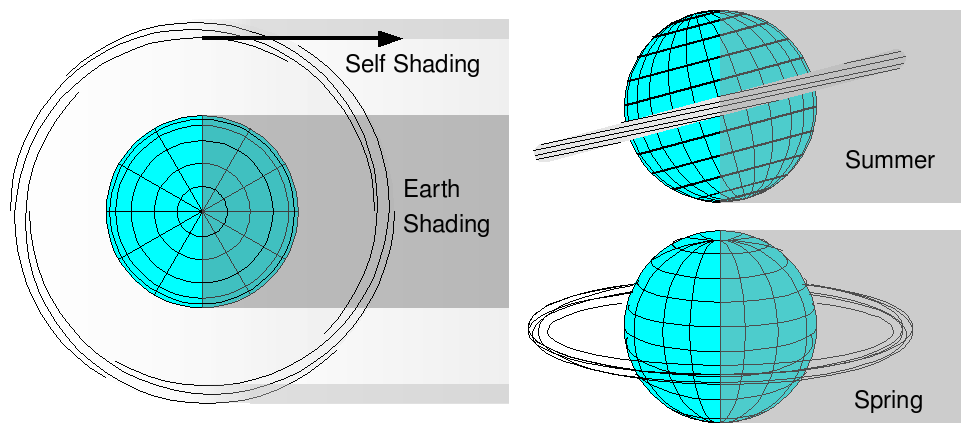
Server-sats will be spaced perhaps 100 meters apart in an array - an array with 32768 server-sats will be 3.2km on a side. This puts them far enough apart that the shade area behind one 0.3 meter diameter server-sat will never completely block sunlight to the server-sat behind it. If the nested tori extend outwards to 500 km around the central orbit, that is a spatial volume of 6E10 cubic kilometers. Potentially, that is room for 60 trillion server-sats at an average 100 meter spacing. This "fuzzy toroidal cloud" of server-sats will block some sunlight, both to the server-sats in the back of the toroidal cloud, and to the surface of the earth. With 60 trillion 300mm diameter server-sats, the light blockage to the ground would be about 14% at noontime near the equator, with the blockage zone following winter as shown above. The blockage of back server-sats near the sides of the orbit would be more severe - at the equinoxes, it could be as much as 95% for portions of a fully populated array. However, it is hard to imagine needing that many server-sats, even if they were operating mostly as space solar power satellites, beaming about 5 watts each to the ground, as that far exceeds the projected world demand for electricity. With a "mere" 10 trillion server-sats, the blockages would be 2% to the ground and 38% to the back of the array. Also, for power production (and one-way information broadcast) ping time is no longer an issue, so m360 and higher orbits can be used.
Nighttime Illumination
Server-sats will reflect some light. Oriented directly at the sun, most of the reflected light will go back to the sun, but some reflection will be diffuse and off angle. The sum of the diffuse reflected light from trillions of server-sats will appear as cloudy light in a band around the equator, interrupted by the Earth's shadow. At the equator, the illuminated bands will be about 9 degrees wide, and travel up from the horizon to within 30 degrees of zenith, and will be brightest just before the terminator. How much light? For 10 trillion (1E13) server-sats, a very full constellation, the total light will be about 20 times the total light from the full moon. The moon has an albedo of 0.12, and so it reflects about 1.5E15 watts of light into a solid angle of 2pi steradians. At 384000km away, we see about 1.6 milliwatts of light per meter2 ( approximately 0.27 lux). A serversat will diffusely reflect perhaps 5% of the 130 watts of sunlight hitting it. The visible 1/3 of 10 trillion serversats would reflect 2E13 watts of light, also into a solid angle of 2pi steradians. At an average of 10000 kilometers distance, the surface at the equator gets about 30 mW/m2, or approximately 5 lux. Since recommended office illumination is about 300 lux, that is way too much nighttime illumination!
Without much better control of reflection, the total number of server-sats in at m288 will be limited by light pollution, probably to a small fraction of full moon light. This will probably limit the near-earth constellation to about 100 billion server-sats.
If 10 trillion server-sats are deployed deployed as far out as the earth-moon L4 and L5 Lagrange points, the situation is much better. The constellations will be visible as often as the moon, though 60 degrees offset to east or west. On average, each constellation of 5E12 serversats will be reflecting 3E13 watts, and at the same distance as the moon, each will appear to be about 2% of the brightness of the full moon.
It is even better at the earth-sun Lagrange points. We can dissipate another 100 Terawatts if we allow the earth to heat up by 0.4C. If that power is produced by 10 trillion server-sats, the reflected light might be 6E14 watts (we can see the whole constellation), but the light reaching us 150 million kilometers away is only 4 nanowatts/m2.
Elevation above the horizon, interference with geosynchronous satellites
Assume that the first torus to be filled with arrays is at a minor radius of 200km from the central orbit. Refraction will lift the apparent elevation of the central orbit a few degrees above the horizon, so a south-facing antenna at 60 degrees north or south may be able to see the edges of the torus. However, ground sites further north or south of the central band may need to relay through other satellites, or through landlines on the ground. For latitudes between 10 degrees north or south, the torus will have similiar ground antenna elevation angles as geosynchronous satellites. Assuming that the same satellite frequency bands are used for server-sky as for existing geosynchronous services, latitudes between 10 degrees and 60 degrees north and 10 degrees and 60 degrees south should be able to make direct use of server-sky.
Intentional gaps in the constellation
The orbits will not be completely filled - there will be large gaps in them to permit transit of launch vehicles. Establishing these "windows" will involve lots of negotiation, beyond the scope of this document.
If it ever proves practical to build space elevators, there will need to be other gaps in time and "property" so that the elevators and the server-sats never interact. A failing space elevator will collide with an undetermined number of server-sats (as well as destroying all the other space elevators), so space elevators and the permanent use of these orbits (or possibly any near-earth orbit) may prove incompatible.
In the short term, there will be millions, not trillions, of server-sats. They should still be assigned positions and orbits compatible with a much more crowded sky. It is good to know, going into this, that the region available for well behave server-sky orbits offers much room for growth.
Defining Property Within the m288 toroid
All server sky orbits in the m288 toroid will have the same identical semi-major axis, and hence the same identical 288 minute synoptic period, and the same 14393 second sidereal period. If the orbits are mapped correctly, every item in them will maintain the same approximate spacing to neighbors in three dimensions, even as the whole constellation makes one orbit around the earth and one "short axis rotation" around the central orbit. This allows very large numbers of server-sats to be deployed in the 60 billion cubic kilometers of server sky. Properties can be assigned much like IPV6 address space is assigned by ICANN - indeed, we may map IPV6 addresses onto particular orbital volumes, and know where in the sky a particular server-sat is from its IPV6 address, or vice versa. If we map down to one meter cubes, we will need about 65 bits of address space.
The space does not map in a rigidly cartesian way; the "toroids" we are mapping on are slightly distorted from perfectly circular minor cross sections, as shown:
|
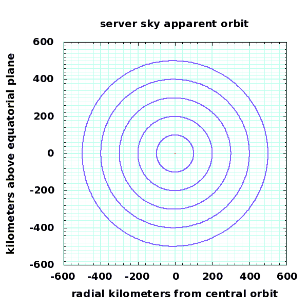
500km cross section of nested torii around the m288, 12789km central orbit region. The outer orbits shown have an eccentricity of 0.039 and an inclination of 2.24 degrees. Although these torus cross sections look circular, they are actually distorted by as much as 3 kilometers from perfect circles. The outer torus has a volume of about 60 billion cubic kilometers. The inner torus, with a radius of 100km, has a volume of 2.5 billion cubic kilometers. |
|
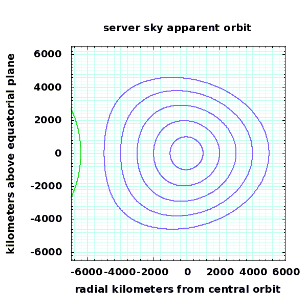
5000km cross section of nested torii around the m288, 12789km central orbit region. The outer orbits shown have an eccentricity of 0.39 and an inclination of 23 degrees. The edge of the earth is to the left. These unusually broad toruses demonstrate the distortion that occurs in outer orbits. The outer torus has a volume of about 6 trillion cubic kilometers (the earth is 1.09 trillion cubic kilometers), a perigee of 1411 kilometers altitude, and intercepts the orbits of many existing satellites and large debris objects, so such large torii should not actually be used. |
In addition, objects in the orbits will be advanced or delayed because of increased velocity at perigee and decreased velocity at apogee. This tends to spread objects near perigee (in the line of the orbit) by 1+eccentricity, and near apogee by 1-eccentricity. Thus, the volume elements will lengthen and shorten, and distort trapezoidally (proportional to the eccentricity, or the toroidal minor radius divided by the major radius) as they travel around the orbit. The arrays within those volumes will distort proportionally.
The below figure shows 3 orbits with 4 objects in each orbit, spaced at 0.25 times the period. The minor radius of the torus is greatly exaggerated.
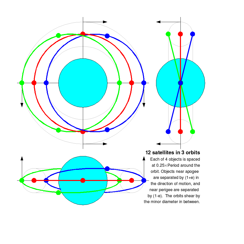
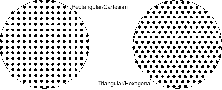
To fill a "torus" with a 3x3 square of orbits, add a rotated copy of the figure by 90 degrees, then rotate the pair by 45 degrees and expand the minor radius by sqrt(2). Then subtract the 3 duplicate central orbits. Repeat at larger spacings, add additional objects on each orbit, and the result is a filled torus (or whatever). This is based on a rectangular cartesian grid mapped into a circle at one angle from the equator to the fixed stars - the prime meridian seems like a good candidate. Other grids, such as triangular/hexagonal, can be mapped within the same circle (a cross-section of the largest torus).
|
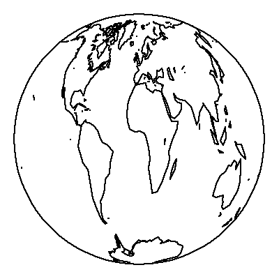
Assigning orbits within this map can be done many ways - by an organization like ICANN, perhaps working outwards from the center in the order of assignment. |
MORE LATER

