Problem: Collisions
First, it is important to understand what space debris collisions actually are. Everything that stays in space is in orbit, and most of those orbits are not orchestrated with each other. Satellites have been placed in orbit for more than 50 years, by inaccurate rockets. The vast majority are derelict, unresponsive, and out of fuel. A significant fraction are rocket upper stages. They are subject to drag, light pressure, gravitational non-linearity, and other orbit modifiers. And most are tracked by a few ground based radars, with limited visibility and atmospheric path distortion. Thus, it is not clear what is up there, and typical prediction errors are on the order of a kilometer.
Still active satellites have limited reaction fuel. Near misses - satellites coming within the 1 kilometer error range - are frequent. Collisions - coming within a couple of meters - are rare, but occur every few years. That creates more debris and more collisions. The frequency of collisions goes up as the square of the density of satellites - much higher in the thin shell of Low Earth Orbit, below altitudes of 500 kilometers or so. The collision frequency also goes up with velocity (higher in lower orbit) and average inclination - highly inclined orbits are more likely to cross paths with high closing velocity.
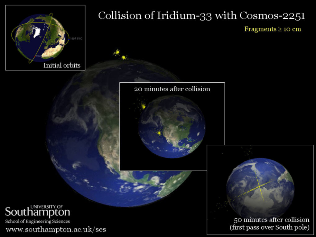
A few collisions have been intentional - Anti-Satellite Warfare tests, most recently by China. Typically, the collisions that make the news are between valuable satellites and old derelicts. One such collision occurred in 2009, between one of the 78 Iridium communications satellites and a derelict Soviet Cosmos military satellite. This collision occurred over the north polar region, where there are no tracking radars, and orbits are inaccurately modeled.
Server Sky Collisions
Server Sky arrays will eventually fill large regions of space. They will all be traveling in the same large pattern, in allocated orbits with the same period, all surrounding a central equatorial orbit. Nearby thinsats will be moving at nearly identical velocities. A constellation of server-sky arrays will never be in self-intersecting orbits. They can only - potentially - collide with other objects that cross their orbit.
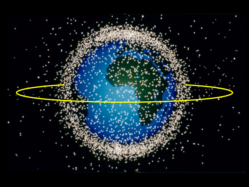
Most objects are in low earth orbit, a few are in GPS and Geosynchronous orbits. Here's a point plot of some of those objects at one point in time, with an M288 server sky orbit added. M288 is far above most of those objects, most of the time.
That plot is not very informative, it does not show orbits that cross the server sky orbits. The following is an "H-V" plot, showing complete plots of orbits, mapped onto a plane with the vertical axis corresponding to the north-south distance ( that is, distance from the equatorial plane ) and the horizontal axis corresponding to the radial component parallel to the equatorial plane. All earth orbits either cross the equatorial plane twice per orbit, or are confined to it as a special case. This plot goes as far out as the geosynchronous region. Green represents currently or formerly in-use satellites, red represents debris, old rocket bodies, etc.
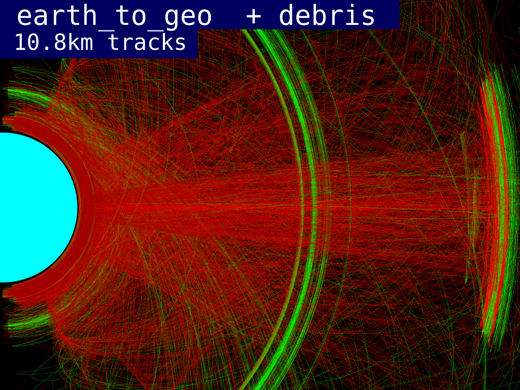
Observe that most of the traces are red - useless junk - and only a few are green. Only a fraction of those green traces are still-functional satellites. The green band near the Earth is mostly Iridium and Globalstar comsat constellations, in highly inclined (and collision-prone) orbits. Halfway across the graph is the GPS and Glosnass navigation satellites, also in highly inclined orbits. The green traces on the right are geosynchronous satellites, mostly defunct communication satellites in "parking orbits". The active geosynchronous satellites would form a small green dot exactly on the equatorial plane. They are in near-circular equatorial orbits.
The plot out to geosynchronous (altitude = 35786 kilometers) is not very useful for evaluating collisions with server sky at 6411 kilometers altitude. Let's zoom in:
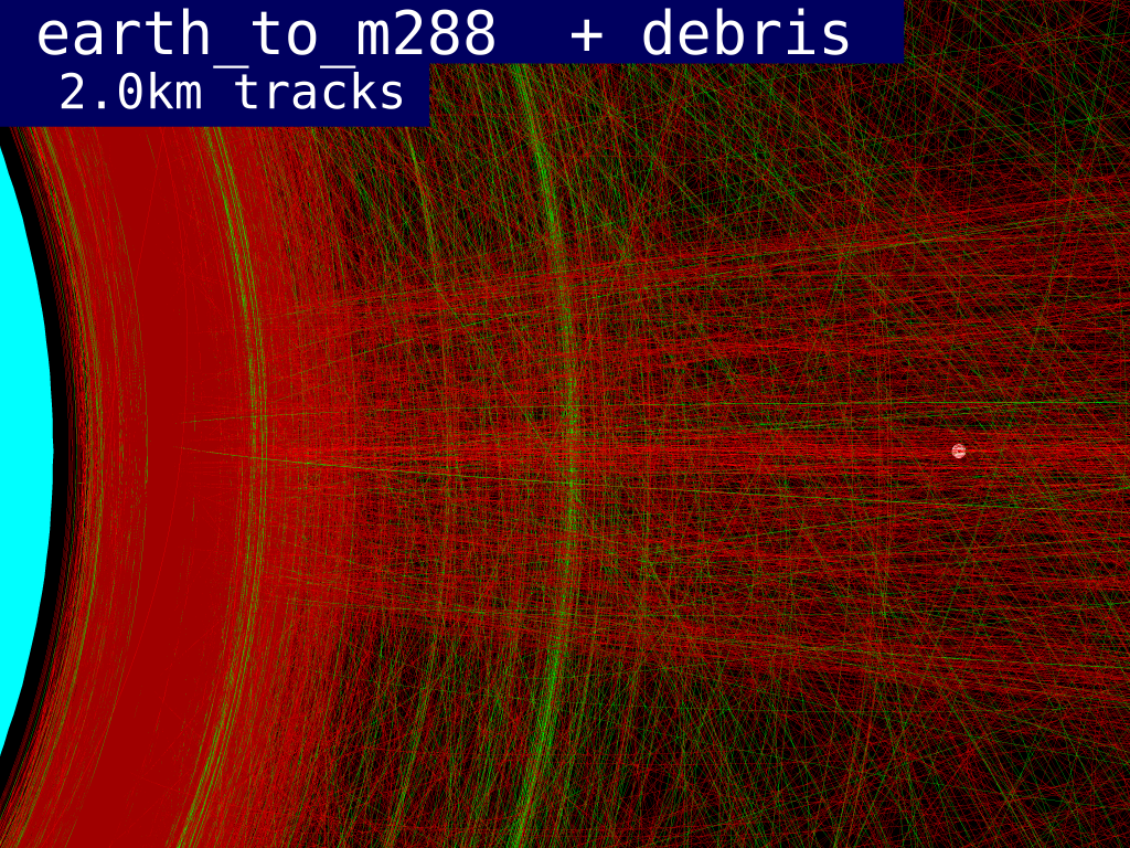
The white dot represents the 100 kilometer diameter m288 region in which server sky will first be deployed. This region is relatively sparsely populated compared to low earth orbit. Remember that collision rates are proportional to population squared, and to inclination. Let's zoom in again, and slow just the region around server sky:
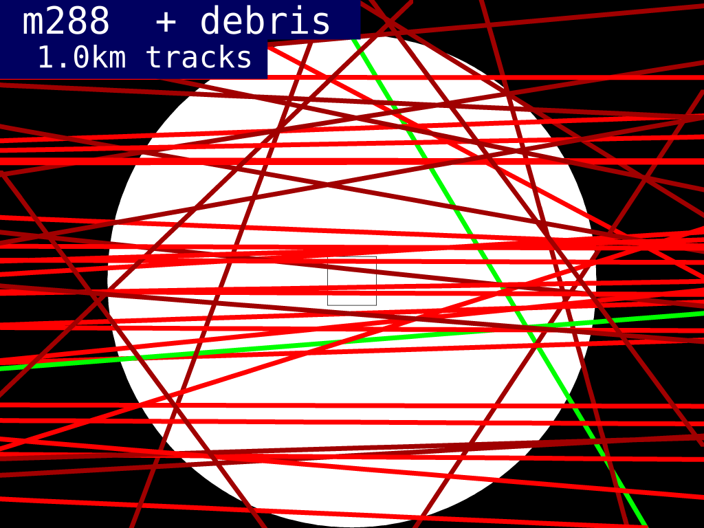
About 100 orbiting items pass through the m288 region. The two green traces represent two satellites, one defunct and the other attached to a malfunctioning upper stage that did not insert it properly into geosynchronous orbit. The width of these traces are 2 kilometers, representing the orbit prediction error in 2011. Nothing traveling through m288 is valuable - it is junk that should be de-orbited, or else gathered someplace else and reprocessed into something useful. So the only reason we are worried about these objects is because we don't want them damaging thinsats and creating more orbiting debris.
The white areas in the circle represent orbits for thinsats with zero chance of collision with these junk objects. There is a lot of white in the plot. Better radar will make the traces of the colliders smaller - more white area - but will also reveal smaller bits of orbital debris, adding more red traces across the plot, and making the usable area smaller. Thinsat arrays can maneuver 1 kilometer in 4 hours, less than an orbit time, so even if one of these potential colliders move, arrays can easily be moved out of the way. As accuracies improve, colliders can be avoided with smaller and quicker movements.
Most of these colliders will be asynchronous with the 288 minute orbit, so they will come through different parts of the constellation at different times. If the colliders are in 6 hour orbits, they will pass through a particular 1km3 region within the trace shown above every 55 years. Plenty of time to watch, and get out of the way. And since most passes will be misses, and since the arrays have large gaps between thinsats, the destruction rate of thinsats will be very, very small, even without maneuvering. The debris from such collisions will tend to traverse regions with few active satellites, well below GPS and well above Iridium. If the debris drops to Iridium levels, drag will rapidly remove it.
In between LEO and GPS orbits, there are a few objects in elliptical transfer orbits - mostly spent rocket boosters and failed satellites. Since most of these transfer orbits are inclined, they only cross the equatorial plane in two places. If those crossing places are at higher or lower altitudes (99% are) they will not intersect a server-sky satellite until their orbit changes significantly.
Because thinsats use light pressure for maneuvering, they do not run out of fuel, and will remain in position as long as at least a portion of the redundant control circuitry is still operable. If a thinsat fails completely, another thinsat can slowly push it towards a disposal area. Unlike traditional big-iron satellites, a server sky array will never go dead and out of control - when obsolete, an array will gather in one place and wait for disposal.
Thinsats can act as orbiting phased array radar illuminators. In combination with sensitive dish receivers, they can locate and track orbiting objects, even small ones, that might eventually pass through an array and possibly cause damage. In a day or two, an array can reposition itself away from the path of the collider. This is another advantage of an "infinite fuel supply". If the server sky data is good enough, it can be used to accurately predict collisions between other satellites. Server sky technology can potentially greatly reduce satellite collision rates.
Carefully positioned gaps in the clouds can be allocated to provide safe passage for objects passing through, such as high orbit launches.
Even if an array completely loses control, and thinsat light pressure shifts the orbit so that perigee is in the densely occupied low earth orbit region (where all collisions to date have occurred), the thinsats are soon cleared out of that orbit by atmospheric drag. The "ballistic coefficient" is so very small that even the residual gas at 1000 kilometers altitude is enough to decay the orbit in a few years. At the 300 kilometer altitude of the international space station, the drag is enough to bring down a thinsat in hours.
In the distant future, we may launching billions of thinsats into orbit per day. We will be launching much thinner satellites to much higher orbits, well above geosynchronous orbit. From there, the delta-V to earth escape is smaller than the delta-V to earth reentry. If we lose control of all of them, only a few will return to earth, and they will do so over a very long time. Meanwhile, perhaps a thousand tons of meteoric material falls to earth every day, and a lot more passes by the earth. So the additional effect on orbital assets will be small, and if we have lost control of server sky, we have probably lost control of those assets, too.
It is hard to imagine a scenario where server sky adds to the existing space collision problem. Different altitudes, different orbital planes, better control, and active collision warning and avoidance, along with an aggressive program to remove obsolete thinsats, will make server sky an essential part of the solution.
Kessler Syndrome estimates of "critical mass" are relevant at some density of occupation.
Space Elevators
If space elevators ever come to pass ( launch loops are more likely ) they will pass through the orbital plane of the thinsats twice a day. Gaps must be created for them. However, a failing space elevator cable will likely sweep through areas without gaps. In a densely populated server cloud, this may smash many thinsats, and the flying debris from those might damage more. Eventually, the non-synchronous debris will slow down to cloud velocity, but not before it bumps into a lot of thinsats. Cleanup after a space elevator failure will be expensive.
